


As the title says today was very up and down. I was working out my route last night on google maps and there was no way I could re jig the route to make me stick on the flats without having to wire down turn by turn on paper as it was getting complicated. So I decided to set off on the original route that would take me bit further into the countryside. It was soo hilly, and not massive hills like day 6, but 10-15 minute climbs followed by a quick downhill coast and then another 10-15 minute climb all over again! I think that I feel more tired today than I did yesterday riding near on 100 miles! The legs are in serious need of a sports massage!
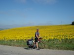
The day started out pretty overcast and as I got further on into the countryside there was lots of cloud about, the sun soon made this disappear and I think it must have been the hottest day yet! As you can see from the photo with the nice background my top isn’t very dry! I actually think the Avis logo looks better in sweat!
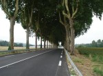
As I got back down out of the countryside and hit the flats again, the roads all look very similar. Its the photo of the road lined with trees. These were next to the road on my way out of Agen and also on my way into Toulouse. They sort of remind me of that road in Bournemouth where all the expensive houses are. Cant remember the name of it, but maybe some of you will recognise what I’m talking about.I nearly added to the road kill today, I was speeding down this hill at about 30 mph, and as I went round the bend these 2 birds were just walking about the road, they took off and I narrowly missed one of them. Would have been an interesting add to the list, one of my own! Today though I did see a Lizard!
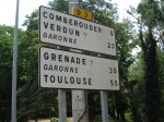
I had to take a picture of the warning sign by the roadside, I’ve seen quite a few of these throughout my French ride, this one looked a little different. Is there a new species of Flying Deer down in these parts!? Apparently able to jump 3km high!If you click on the link below it will bring up the route I did today on google maps. I’ve got it set to show the terrain so you can see just how hilly it really was. There’s also a pic below of one of the down and ups I had to do, its so hard to motivate yourself when you’ve just reached the top of one climb and you look across the landscape and see your next one.
Fortunately tomorrow shouldn’t be like today as my route keeps me within the flats, with it just being 63 miles, I’m looking to get there as early as possible and rest up.
Today’s journey was 71.29 miles, riding time of 5:35:09, max speed 33.1 mph, avg speed 12.76 mph, 4460 calories, 3.15 litres so far.
